5/25/2010

Börzsöny


We were at Pentecost for
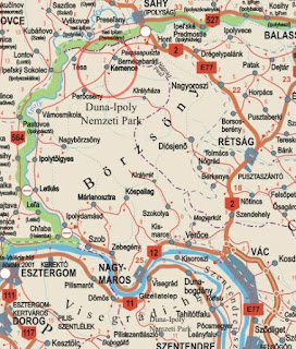
3 days in reserve Börzsöny Mountains in northern Hungary, about 100 km from Budapest, near the Slovak border. It is of volcanic origin. On a former crater rim are the highest peaks in the Börzsöny, including the Csóványos, which is 938 m with the highest elevation in the mountainous region. The area covers the area of about 400 km. Most of the natural sources for its many well-known area is protected.In the north of Magas-Börzsöny Kemence is the stream that borders the northern part.(The name derives from the Slavic word from Kamenica, which means "stony river bed.") The area can be further divided into two main parts,separated by a valley from each other. The northern part consists mainly of sedimentary rock that was created prior to the volcanic activity. In contrast, the South lava is the predominant substrate.


To the rich wildlife of the area also includes the stock of big game, including deer, wild boar, roe deer and even the mouflon. Often come pheasants, foxes before, hares, badgers, martens, weasels and otters. The birds of prey include the Eastern Imperial Eagle,Saker Falcon of the hawk and the goshawk. The best-known songbirds are the nightingale, the thrush and the lark. In the village there is a
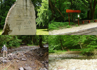
forest Kemence and Museum Railway. This is the only railway line in Hungary, which is operated solely by volunteers work. Technical special feature of this railway is the 600 mm gauge, and a special expansion of the trail. The course is developed so that there is a continuous gradient (which was previously necessary for timber transport). The village inhabitants Kemence i1174, and was in the XVIII. Century, the capital of the garrison county Hont. Kemence is today one of the Pest County, and is one of the tourist center of the area.


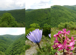
Wir waren am Pfingsten 3 Tage lang in Naturschutzgebiet Börzsöny-Gebirge ( deutsch Pilsengebirge ) in Nord Ungarn, ungefährlich 100 km von Budapest, nahe der slowakischen Grenze. Es ist vulkanischen Ursprungs. An einem ehemaligen Kraterrand befinden sich die höchsten Gipfel des Börzsöny, darunter auch der Csóványos, der mit 938 m die höchste Erhebung des Mittelgebirges bildet. Das Gebiet erstreckt sich über etwa 400 km² . Der größte Teil des für seine Vielzahl an natürlichen Quellen bekannten Gebiets steht unter Naturschutz. Im Norden des Magas-Börzsöny bildet der Kemence-Bach die Grenze zum nördlichen Teil. (Der Name leitet sich vom slawischen
Wort kamenica ab, das soviel wie „steiniges Flussbett“ bedeutet. ) Das Gebiet lässt sich weiter in zwei Hauptteile gliedern, die durch ein Tal voneinander getrennt sind. Der nördliche Teil besteht größtenteils aus Sedimentgestein, das bereits vor der vulkanischen Aktivität entstanden ist. Im Süden ist dagegen Lavagestein das
vorherrschende Untergrundmaterial.


Zu der reichen Tierwelt des Gebiets gehört auch der Bestand an Großwild, darunter der Rothirsch, das Wildschwein, das Reh und auch das Mufflon. Häufig kommen Fasane, Füchse, Feldhasen, Dachse, Marder, Wiesel und Fischotter vor. Zu den Raubvögeln gehört der Östliche Kaiseradler, der Sakerfalke, der Sperber und der Habicht.
Die bekanntesten Singvögel sind die Nachtigall, die Amsel und die Lerche.
In Dorf Kemence findet sich ein Wald- und Museumsbahn. Diese Eisenbahnlinie ist die einzige in Ungarn, die ausschliesslich durch Freiwillige Arbeit betrieben ist. Technische besonderheit dieser Eisenbahn ist die 600 mm Spurweite, und eine besondere ausbau der Strecke. Die Strecke ist so ausgebaut, das es eine kontinuierlich Steigung gibt (das war früher für Holzbeförderung nötig). Das
Dorf Kemence i1174 Einwohnern, und war in der XVIII. Jahrhundert das Hauptstadt den Burgkomitat Hont. Kemence gehört heute zu das Komitat Pest, und ist eine der touristischen Zentrums der Gegend.

5/17/2010

Bupa Great Manchester Run

Haile Gebrselassie has won the Great Manchester Run for the third time, but strong winds kept him from posting a fast time in the 10-kilometer race. The 37-year-old Gebrselassie finished in 28 minutes, 2 seconds, which was 23 seconds off his winning time last year.

Marathon-Weltrekordler Haile Gebrselassie (Äthiopien) gewann am Sonntag zum dritten Mal nach 2005 und 2009 den Great Manchester Run (Großbritannien). Die 10 Kilometer absolvierte der 37-Jährige in 28:02 Minuten.


Ors also started the race. The race had 33,000 participants. His time was: 00:47:34.
Ors begann auch das Rennen. Seine Zeit war: 00:47:34.


Örs with Haile / Örs mit Haile :)

5/16/2010

BÜKK

Es war schon eine Woche vor, daß wir in Bükk -Gebirge einen Ausflug machten, endlich hatte ich Zeit um ein Post zu schreiben. Diese Woche war das Wetter sehr schlecht, so das nicht um inspiriert mich zu schreibe und meine Fotos, Videos zu lange Zeit stellen unfertig, und endlich mußte ich Arbeiten auch. Am Samstag reisten wir mit Bahn nach Miskolc, und von hier weiter mit Bus nach Lillafüred, hier war unsere Herberge. Samstag mittags haben wir eine kleine Tour gestartet und wurde durch eine schwerere Sonntag und Montag folgten auch einen halben Tag, nachmittags, ging nach Hause. Ein paar Tage vor unserer Ankunft war eine große Regenfall, richtung Lillafüred auf der Straße 60 cm Wasser floß, und daher sind für Autos gesperrt vor. In die Bergen sahen wir auch viel Wasser, kleine Wasserfälle in den Bächen ins Tal läuft, wir den Schlamm auch eingewöhnt sich. Am Sonntag nachmittags es regnet war, für kürzere Zeiträume, Tag und Nacht gesunken, hauptsächlich nur still, aber manchmal in einen Sturm liegt nur wenige Minuten. Wenn ich aus dem Fenster schauen jetzt - es gießt, und stürmisch Wind weht - wir hatten Glück mit unsere 3 Tagen. Wir fuhren mit Waldbahn, wanderten 38 km, wir sahen schönen Buchenwald , Aussichtspunkten, unsere tapfere Freunden bewunderten zwei Höhlen, auch den Wasserfall Lillafüred, einige von uns am Hamori See fuhren mit Boot ,natürlich wir aßen und tranken, gute Dinge und haben wir gefeiert zwei Geburtstag. Hier sind einige Fotos, und der Rest auf der rechten Seite der "My Photos" kann man sehen.


We’ve been to the Bükk a week ago, now I finally got to write about it. This week the wheather was awful, so it didn’t really inspire me to write, and I lagged behind with the photos and videos as well, and - by the way - I had to work too :)
We travelled to Miskolc on Saturday, then to Lillafüred, where we had our hotel. At noon we were already off to a short excursion, which was followed by a longer one on Sunday, then by another one on Monday, then we went back home the same afternoon. A few days before our arrival it rained a lot, on the way to Lillafüred 60 cm high water was flowing, so the road was closed down for the cars. Even during the excursions we had plenty of water, the streams were running down to the valley with small waterfalls, in the end we already got used to the mud. We managed to avoid the rain until Sunday afternoon, after that it’s been raining day and night, with smaller breaks. Luckily it was only spitting most of the time, but sometimes we’ve been caught by a few minutes long rainstorm as well. If I look out of the window now, it is pouring and high wind blows – we were lucky in those 3 days. We travelled with the forest railway, we walked 38 km, we’ve been to beautiful panoramic viewpoints and to wonderful forests, the braver ones entered to the cave as well. We admired the waterfall of Lillafüred, some went to boat on the Hámori Lake, and of course we ate and drank well, and we celebrated two birthdays as well. Here are some pictures, you can take a look at the other ones by clicking on ’My Photos’ on the right side.

5/01/2010

Körös-Maros National Park /Nationalpark/Parc National


Stretching from the foot of the hillside across in Romania to the River Tisza, the Körös-Maros National Park preserves the remaining assets of this unique landscape. Most of these treasures are connected to water: the river systems and oxbow lakes of the area between the River Körös and River Maros, the floodplain forests, the Sárrét swamps and the associated saline meadows. This area has been protected since 1997. There are rare animal and plant species which either in Hungary breed only here, or the largest populations of these species find suitable conditions here. In the Körös-Maros valley the geographical units of the national park have remained as islands. These are bordered by the Körös rivers to the north, the River Maros to the south, and the River Tisza to the west. There are floodplain forests, willow-poplar scrubs and groves. The former riverbeds and meadows remaining inside the flood area evoke the former swamp world of the Great Plain. The floodplains are home to numerous waterfowl.

The Devavanya-Ecsegpuszta of the Körös-Maros National Park preserve many different habitats. The 20 kilometre unregulated and protected stretch of the River Hortobágy-Berettyó acts as an important bird habitat. Water chestnut, which is on the European Red List of threatened species, grows here in large numbers. The water chestnut has been used as a flour substitute during times of famine, while more recently it has become an ingredient of gastronomic specialties.

To protect the Hungarian great bustard population, the Great Bustard Reserve in Dévaványa was founded in 1975. The Réhely Visitor Centre between Dévaványa and Ecsegfalva is an exhibition site of the national park where an overview of the natural assets and bustard conservation work in the Great Sárrét is presented. There is also a nature photography exhibition and specialist lectures are held. Expert guides to the nature conservation areas and bicycle hire are available here.
The Kis-Sárrét national park unit conserves the most important remnants of the swamp world of the Sebes-Körös. The fishing lakes of Biharugra support an invaluable asset: the rich bird life. Among the mammals, one of the strongest communities in Hungary of the strictly protected otter lives here in the lakes and channels. One of the most significant natural assets of Southern Transdanubia is the White Lake (Fehértó)at Kardoskút which evolved from a former side branch of the River Marós. This alkaline area with its distinctive puszta ground cover and animal life along with its highlighted role in bird migration led to its inclusion under the Ramsar Convention in 1979. The White Lake and its immediate surroundings are strictly protected and may only be visited with permission. There is free access to the protected areas but the rules of nature conservation must be adhered to. At important spots information boards provide orientation. The strictly protected areas can be visited with special permission from the National Park.

Der Nationalpark Körös-Maros wurde als siebenter Nationalpark am 16. Januar 1997 in Ungarn gegründet. Die Gebietsteile gehen wie ein Mosaik ineinander und befinden sich in der südöstlichen Tiefebene. Die Gesamtfläche beträgt 51.125 Hektar, von denen rund 6.000 Hektar einem ganz besonderen Naturschutz unterliegen. Einen sehr wasserreichen Lebensraum bieten der Kardoskúter Fehérto und die Kis Sárrét, was für Zugvögel sehr bedeutend ist.
 Von seiner Landschaft her ist dieser Nationalpark sehr unterschiedlich und doch sind sich die Gebiete in ihrer Entstehung recht ähnlich. Das Gebiet besteht im Grunde aus zwei Landschaftseinheiten, so dient die Körös-Gegend und die ehemaligen Gebiete von Groß- und Kleinsárrét im Komitat Békés, der Erhaltung der alkalischen Puszten, der Erhaltung der verbliebenen Sumpfgebiete und der bis heute existenten naturnahen Wälder. Die andere Gegend sind die Kigyósi- und Csanádi-Puszten, der Kardoskúter Fehértó sowie die ehemaligen Überschwemmungsgebiete der Maros. Letztere sind bis heute in ihrem ursprünglichen Zustand erhalten und zeigen ein deutliches Bild der ehemaligen Landschaft.

Im Nationalpark gibt es viele einzigartige, botanische und zoologische Raritäten und in der Dévaványa-Ecsegfalva gibt es die größte lebensfähige Population der Trappen in ganz Ungarn. Im Jahre 1975 wurde hier ein Trappenreservat eingerichtet, das sich auf den Schutz und der Erhaltung dieser Tierart konzentriert. Ein besonderes Augenmerk wurde hier auf den Schutz des frei lebenden Bestands gelegt. Daher werden ruhige und weiträumige Balzplätze in der Puszta zur Verfügung gestellt, ein Nestschutz gewährleistet und die Fütterungsbasis gesichert. Die Erkundung dieses Nationalparks ist auf beschilderten Wegen möglich.

Le Parc National Körös-Maros a été créé en 1997. Il est situé au Sud-Est du pays. Il recouvre les systèmes d'eau des fleuves Kőrős et Maros. Le parc national a beaucoup d'espaces colorés tels que le marais Kis-Sárrét, Fáspuszta, Mágor-puszta, Kardoskúti Fehértó. Sur le territoire du parc, il y a plusieurs plantes et espèces d'animaux uniques et protégées telles que l'outarde, la huppe, un oiseau indigène d'Europe du sud, d'Asie et d'Afrique du Sud ou le búbos banka et le agárkosbor qui sont une espèce protégée d'orchidées.